Blog

  • How to Weigh Out a Food Portion

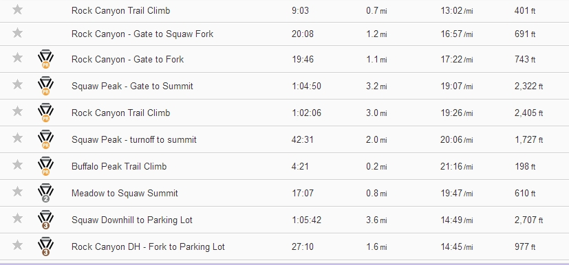
    In my most recent book The 100 Calorie Diet Plan (available in Print on Amazon and Createspace, and for Kindle and for Nook ebooks) I explain a food portioning scheme based in part on accurately weighing out specific food portions of 100 calories each. I’ve had a few people ask about the details on how to do this, so as a supplement to the book, here is a brief article showing an example.

    Nutrition Facts Label for Salted Almonds
    Nutrition Facts Label for Salted Almonds

    A food portion of almonds

    In this example food item, Salted Almonds, the Nutrition Facts Label tells us that 28 grams of almonds is 170 calories. Since we’re looking to have a 100 calorie portion of this food item, we’ll do some simple math to give us the weight of a 100 calorie portion. To find a per-calorie weight, we divide 170 by 28, and then divide that into 100 to find the weight of our food portion.

    Divide 100 calories by the  calories per weight of your food item
    Divide 100 calories by the calories per weight of your food item

    For simplicity in our calculations, that’s 100 / ( 170 / 28 ) which gives us a little over 16 grams, which we round down to 16. Next we set the scale to zero with a little food container on it. Because this is a snack in the middle of the day for me, I’m going to just use a little plastic bowl. For many people this works good because then they can just dump it from the little bowl to their storage container or baggie and just keep weighing with the same bowl. For my scale, I set the bowl on it then turn it on and it automatically zeroes the scale.

    Set the scale to zero with your weighing container on it
    Set the scale to zero with your weighing container on it

    Next carefully dump the almonds or other food item into the bowl until you get the weight you calculated from the Nutrition Facts Label, in this case 16 grams. I prefer grams because it’s fairly precise and most labels or charts will give a food portion in grams.

    100 calories of salted almonds is not a lot of almonds
    100 calories of salted almonds is not a lot of almonds

    Surprisingly, that’s not a lot of almonds. Nuts are a fairly calorie dense food item, with only a few almonds equaling 100 calories. In my opinion, it’s one of those things that are best used in the form of thinly sliced almonds as part of a 300 calorie salad, with a 100 calorie portion of lettuce and a 100 calorie portion of dried grated Parmesan and a spritz of a low calorie soy sauce or Bragg Liquid Aminos

    body composition improvement evident in fat loss
    Upper back development at 12% bodyfat after losing 60 pounds

    I hope that helps you to understand a little better how to calculate and weigh out a 100 calorie portion of a food item. For my Accountability Partner clients we go into much greater detail for selecting a comprehensive plan with goals and achievements built in.

  • Training Log: Bonneville Shoreline Trail 12 Nov 2013

    Last night I went to bed with a crazy idea. To do a 5K PR on the BST, or Bonneville Shoreline Trail. Along the Wasatch Front of Utah we just call it the BST for simplicity. Everyone who runs or bikes knows it. Here in Utah County it’s pretty dry and barren for the most part. It’s made up of various jeep roads along the base of Mount Timpanogos here in the Northern part of the County. Further South it has a few more trees on it, down by Rock Canyon.

    Just after completing my 5K PR on the BST
    Just after completing my 5K PR on the BST

    I parked at a church near the Cedar Hills Golf Club, since they don’t mind much and the paved rec path is there to access the dirt road. I walked about a quarter mile to warm up, then hit the button on Strava [results] and my Watch. I monitored my progress closely, with the Pace View on the watch to make sure I stayed below a 10:00 pace, with a target of 32:00 minutes for my PR.

    There were a few steep but short hills and a few longer gentler uphill grades, and I had to walk a few times. Then at 1.6 miles I turned around and gave it a little more speed. My legs and lungs were sore and I came in at the starting line, about 3.2 miles and then tapered to a walk to let my heart rate decrease. When I uploaded the run to Strava it did in fact meet my goal at 31:25 for the 5K PR.

    Later I looked at my Polar results and my heart rate was over 160 for almost the entire return 1.6 miles. Awesome job, if I do say so myself. Below is the GPS track from Strava and then a gallery of some of my results graphs from Strava and Polar.

    [map style=”width: auto; height:500px; margin:20px 0px 20px 0px; border: 1px solid black;” gpx=”http://fps.dzl.mybluehost.me/website_031b6ccf/blog/wp-content/uploads/BST PG 5k 12 November 2013.gpx”]

    Map and Splits
    Map and Splits
    Pace Overview - Elevation and Pace
    Pace Overview – Elevation and Pace
    Pace Analysis - Splits
    Pace Analysis – Splits
    Pace Analysis - Smoothed
    Pace Analysis – Smoothed
    Pace Distribution based on Tempo
    Pace Distribution based on Tempo
    Polar Heart Rate (in the red zone)
    Polar Heart Rate (in the red zone)
    Polar Heart Rate Zone Displayed
    Polar Heart Rate Zone Displayed
  • Training Log: Squaw Peak 02 November 2013

    I was going to be in Utah for family business and had contacted fellow Team Seven Summits Quest member Jen Hamilton to see if she could do a run on it. She was planning on starting around 7, and I couldn’t be there before 9, so I thought we could hook up on the trail.

    Charles Miske and Jen Hamilton below Squaw Peak overlooking Provo Utah
    Charles Miske and Jen Hamilton below Squaw Peak overlooking Provo Utah

    I had two days of rest after my slow winter conditions run on Quandary, so I was hoping I could beat my last PR on Squaw. I took off from the parking lot and tried hard to run up the road, then gravel road, then narrow four wheel drive road up to the fork in the trail for Squaw, about 1.5 miles from the gate to the parking lot.

    Squaw Peak map with Splits
    Squaw Peak map with Splits

    I ran about a 10:00 pace for the paved section of road, then settled into about a 15:00 uphill walk with a few steep sections of slower walking, trying hard not to drift below a 20:00 pace. I figured with a two hour head start I might be running into Jen somewhere up the fork, probably on her way down. I looked at my watch and saw that I was running a few minutes slower than I thought I needed to be for a PR.

    About a half mile from the summit of Squaw Peak [photo by Jen Hamilton]
    About a half mile from the summit of Squaw Peak [photo by Jen Hamilton]

    The trail devolved into slimy mud over frozen hard dirt with some ice and snow in shady places. With the fallen leaves it was a bit slippery in places. I finally ran into Jen about a half mile from the summit as she was descending. We talked for a minute and I checked my watch. I felt like I was about four minutes off from a record, and after a couple minutes we decided to meet on my way down and I ran hard for the summit.

    Squaw Peak Summit
    Squaw Peak Summit

    I checked my watch and was a bit fuzzy, since I had started it at the car, and there was a couple minute walk to the gate before the Strava Segment started. I hung out for a minute, took a couple of pictures, then headed back down. It was a bit more slippery going down, and I fell once, but no damage, so I kept on. Jen was moving pretty fast going down, and I ran into her about a quarter mile from the fork to the road and we went down that last steep narrow dirt trough together.

    Frosty branches in the frozen mud
    Frosty branches in the frozen mud

    We continued on back to the car moving at a reasonably fast clip, but not running like I’d done on my last Squaw Peak training run. We discussed Elbrus Race 2014, possible gear selections and training methods, nutrition and her health and training goals.

    It wasn’t until a while later, when I synced my Strava app that I discovered I’d achieved a handful of PR’s on this one. I was surprised, but quite pleased. One thing I’d like to add here is that I was not using trekking poles on this run, so I was using my arms to pump hard on the way up. Not sure if it helped or not though.

    Strava Overview with PR's for Squaw Peak Run
    Strava Overview with PR’s for Squaw Peak Run

    I have been doing the Hoka Vertical Challenge on Strava too, which is one reason I’ve been doing a lot of vertical training this past week, instead of my usual runs on Keystone Gulch Road. I managed to top 4000 meters this week, which is a lot of vertical feet, especially considering that quite a bit of that was accomplished above 4000 meters on a Colorado Fourteener.

    Hoka One One Demand More Vertical Challenge 4000 meter achievement
    Hoka One One Demand More Vertical Challenge 4000 meter achievement

    I’m heading back to Colorado now, and not quite sure what my vertical achievement goal will be for Monday after a rest day on Sunday. It will be exciting though to make this training goal. Here is a collection of images about my training from Strava Reports:

    [map style=”width: auto; height:500px; margin:20px 0px 20px 0px; border: 1px solid black;” gpx=”http://fps.dzl.mybluehost.me/website_031b6ccf/blog/wp-content/uploads/Squaw Peak 02 November 2013.gpx”]

  • Back Hyperextension to Superman Plank

    I do Back Hyperextensions regularly in my training. I usually do them as a warmup for my other training especially on leg days. Getting the lower back prepared for squats and deadlifts is essential. In the video below I demonstrate a decent lower back position when doing Back Hayperextension exercises. Be sure to keep that back straight and don’t let the curve in your lower back collapse, like the classic angry cat image.

    Back Hyperextension: close up of lower back and glute area

    From the Youtube Page: I keep my lower back static while feeling the emphasis in my hamstrings and glutes. It’s not really a workout, but it’s a great way to warm up and cool down from your other posterior chain training.

    In that back hyperextension video you probably notice that I don’t go for a large range of motion. About 45-60 degrees of movement is plenty. If you see someone doing this in a dynamic swinging movement with their shoulder pushed down and pulled back at the bottom and top, don’t imitate them. You can get hurt very badly. I think you should do back hyperextensions slowly and under control. It’s not strength training. You probably won’t be doing this with 200lbs on your shoulders. Ever.

    Back Hyperextension to Superman Plank

    I was talking to one of the people I train about fast uphill motion and they noticed some definite nagging pain in their Quadratus Lumborum area. I recommended back hyperextensions and Superman planks.

    Back Hyperextension target muscle Quadratus Lumborum c/o Wiki
    Back Hyperextension target muscle Quadratus Lumborum c/o Wiki

    While training the other day it suddenly struck me to combine the two exercises into one set. It’s a lot easier since you are already set up to do the back hyperextension, and just lift your arms out for the plank. Here’s the Facebook Video I posted for this combination exercise.

    The usual disclaimers apply. If you are hurt, injured, have some disability or pain or other issues that prevent you from doing this, please, check with a qualified professional before attempting it.

  • Training Log: Torreys Peak via Kelso Ridge – 17 August 2013

    I’ve been wanting to do this one for a couple years now but haven’t quite gotten around to it. This past week I’d done a couple more extreme trail runs. I did a 17.5 mile up Keystone Gulch to the Colorado Trail to the Aquaduct Trail for Breckenridge and back. I was lost.

    I also did a double on Mount Royal overlooking Frisco Colorado. I was pretty wasted so I was looking for something that my friend, climbing partner, and Team Seven Summits Quest mate Todd Gilles and I could do together that was also extreme, but would allow us to go a bit slower than we have been in our training for Elbrus Race 2013.

    Todd Gilles rock climbing on Kelso Ridge
    Todd Gilles rock climbing on Kelso Ridge

    We met in Keystone at about 6:50 and drove together in my higher clearance vehicle to the Grays Peak Trailhead up Stevens Gulch. The Grizzly Gulch Fork parking was completely overparked and as we went up the road through the private land area we ran into a long line of bumper to bumper cars parked along the side. We stopped to ask and no one knew for sure if there were spaces up at the trailhead. I decided to risk it, thinking there would be parking along the road to the mining area where I’d camped several years before.

    Sure enough, there was parking for us and we took off up the trail. It was pretty obvious that many of these hundreds of people don’t get out much. They weren’t at all experienced with faster “hikers” on the same trail. We made it to the fork to Kelso Ridge in pretty good time in spite of that. We took off up the ridge and for the most part it was loose gravel and dirt with a few steep gullies of third class rock, with maybe one or two fifth class moves. I think if you were cautious you could find a way to make it easier.

    We didn’t really push for speed and stayed behind a few people that we used as routefinders for a while until they stopped for lunch. Then we came to the Knife-edge. This was classic. It’s a steep point about 50′ long along the ridge top. The slabs drop a few hundred feet both directions and most people I have heard slide along on their crotch. Some more brave people just walk on it. I was not brave that day. Todd was a bit faster than me. I think his Merrel minimum trail runners had better stick than my Salomon XA-Pro. They felt like they were sliding off every little foothold.

    Happy to be on top. Todd Gilles and Charles Miske after climbing Kelso Ridge on Torreys
    Happy to be on top. Todd Gilles and Charles Miske after climbing Kelso Ridge on Torreys

    The last bit was a scree slog sometimes on hands and knees. At the top we hung out and ate and drank and did pics and videos. On the way down we saw hundreds of people along the trail. Most coming up quite late, but some going down. We got behind some really slow people, even for the slow pace we were going at, so at a switchback with a fork I managed to run around everyone and we started booking it down the trail.

    We passed everyone. Not a single other person, even those dressed as trail runners, passed us. I think it took only a little over an hour to descend back to the car. I know I had a lot of fun sliding and jumping and even falling once to avoid running into a dog in the middle of the trail that didn’t notice me approaching.

    Torreys via Kelso Ridge – Strava Stats

    Torreys via Kelso Ridge 17 AUG 2013 on Strava - overview
    Torreys via Kelso Ridge 17 AUG 2013 on Strava – overview

    When I uploaded my stats Strava associated our stats together, Todd’s and mine. Oddly we were 20 minutes apart though we hit the summit within a minute of each other. I think it was because whoever created the segment pinned the summit in a different spot. I just sat down at the cairn and Todd wandered around, so likely he passed through the pinned segment end before I did. In any case here are the Strava stats [CLICK HERE]

    Torreys via Kelso Ridge Map

    [map style=”width: auto; height:500px; margin:20px 0px 20px 0px; border: 1px solid black;” gpx=”http://fps.dzl.mybluehost.me/website_031b6ccf/blog/wp-content/uploads/Torreys_14er_via_Kelso_Ridge_17_August_2013.gpx”]

  • Training Log: Keystone Gulch Form Run – 19 August 2013

    For this installment of Training Log I’m sharing my run this morning 19 August 2013. It was the first day of school so everyone was up early. I got out of the condo at 7:00 AM and it was pretty cold still. It was damp too, having rained quite a bit yesterday evening.

    Trail run up Keystone Gulch cold morning
    Trail run up Keystone Gulch cold morning

    I was still pretty tired from my big runs and climbs last week, and decided that if I can’t go fast I might as well work on my form. I tried to make nice fast paced little circles with my feet and strike gently for as long as I could. I also tried to reduce my stops, but ended up pausing to take a few pics and vids.

    Strava for the Keystone Gulch Easy Form run 19 August 2013
    Strava for the Keystone Gulch Easy Form run 19 August 2013

    I had planned to run at least a 10k, and it was a bit of a mental game to do that, since the road between 2.5 and 3.0 miles seems steep compared to the rest of it. Here’s the Strava Overview for this run [CLICK HERE]

    Below is the Keystone Gulch Map View

    [map style=”width: auto; height:500px; margin:20px 0px 20px 0px; border: 1px solid black;” gpx=”http://fps.dzl.mybluehost.me/website_031b6ccf/blog/wp-content/uploads/Keystone Gulch Easy (form) 19 August 2014.gpx”]